
Understanding Census Geography
When we work with data, we always work with a place – a state, a nation, a town, etc. In data-speak, these are called “geographies.” Geography means a physical place where the data are connected.
All geographies are hierarchical. The nation encompasses the states, states encompass counties, and counties encompass towns.
Similarly, census geography is a hierarchical structure that ranges from the nation down to blocks. These geographies are used in all Census data products. Data availability varies by source and geography. Also, census geographies can change over time, affecting data comparisons.
Census Data Hierarchy
This graphic visually depicts the geographies that the Census Bureau uses in its data dissemination.
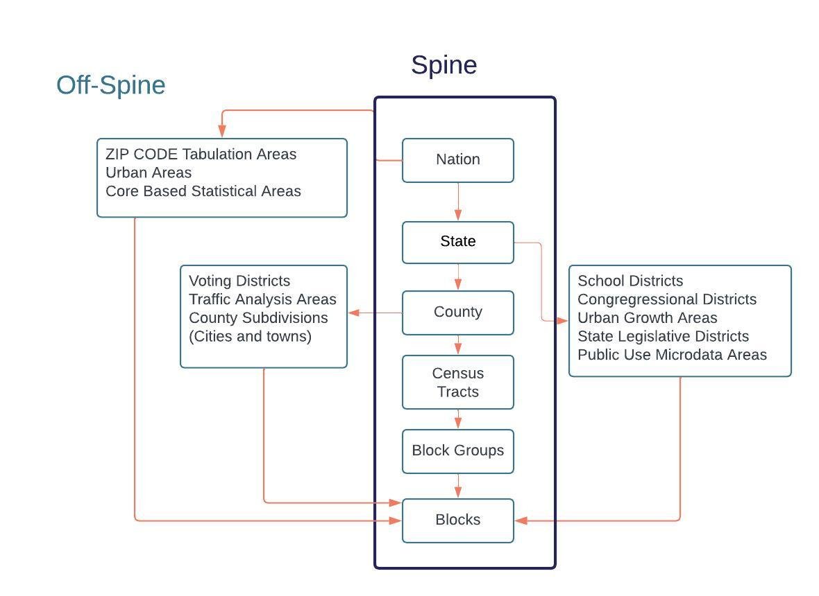
The main geographies are on the “spine.” These are the geographies that are on the centerline, starting with “Nation.” These geographies nest perfectly within each other, from blocks up to the nation.
Geographies that are “off-spine” are likely to have higher error rates in their population estimates and other products than on-spine geographies.
The Nation's off-spine geographies include:
Zip code tabulation areas
Urban Areas
Core Based Statistical Areas
State off-spine geographies include:
School districts
Congressional Districts
Urban Growth Areas
State Legislative Districts
Public Use Microdata Areas
County off-spine includes:
Voting Districts
Traffic Analysis Areas
County Subdivisions( Connecticut’s Cities and Towns)
“Town” is not an on-spine geography; in the census geographic hierarchy, it is called a “County Subdivision.” In Connecticut, we often look at town data by default, yet because “towns” (county subdivisions) are off-spine, they are likely to have higher margins of error than Counties.
Another way to understand the nested geographies is by using data.census.gov. By examining the "summary level," you can see how different geographic entities are nested within each other.

Data Availability Based on Hierarchy
It is important to note that not all census data products are available for all geographies. For example, the American Community Survey's 1-year estimates are only available for geographies with populations of 65,000 or higher. However, for the American Community Survey, 5-year estimate data is available down to block groups.
Data Based on Geography
To illustrate these geographies, we will explore the population of Connecticut's 17 and under population using the 2020 Decennial Census. Connecticut has 736,717 children aged 17 and under.
County
The table below shows this population by count by County. The county populations add up to the state of Connecticut’s population aged 17 and under.
County Subdivision (Town)
The city of Hartford, a county subdivision, has 28,003 children aged 17 and under, which make up 15% of Hartford County's 17 and under population
Important Notes
Understanding census geography is crucial for anyone working with Census data products. The hierarchical structure of census geographies ranges from the nation down to blocks, and it is essential to note that these geographies can change over time, affecting data comparisons. Refer to our Geospatial Data Tools page for crosswalks between various geographic levels and changes.
The most accurate geographies are on the "spine," and " off-spine " geographies are likely to have higher error rates in their population estimates.
Remember also that not all census data products are available for all geographies.
For More Information
If you would like more about the Census and resources provided by CTData, you can head to our Census Data portal. Explore other data sets and analysis at data by topic and data projects. Access our Geospatial Tools or Census Data Tools for your census data project. You can stay up-to-date on the latest data and tools by subscribing to our newsletter and following CTData on Facebook, Twitter, and LinkedIn.