
PUMA Options
UPDATE: CTData met with community members the week of January 3. This blog post captures the decision-making process and the updated maps that are being considered the final decisions for these regions, pending further input from one region. This page will be updated to reflect those options once they are made.
***
Based on the discussions CTData has had with the Census Bureau, these are the current options we are exploring. We invite your thoughts, feedback, and ideas on these options. We will update this page with information about decisions that are made, so be sure to check back here soon. Submit your feedback below.
Learn more about the background of PUMAs and the PUMA delineation process here, or explore maps and tables of Connecticut PUMAs here.


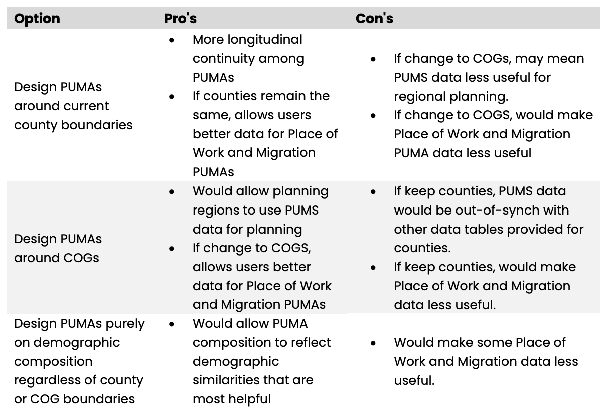
What We Have Learned
We went into this process hoping that we could combine towns into groups of PUMAs that had demographic similarities. However, because of the location of the “county” lines (the planning regions as the new county designations), and the requirement that the population be above 100,000 in a PUMA, we found we had far fewer options than we had originally hoped.
We attempted to combine PUMAs based around regions of different entities in the state (Health Districts, Department of Children and Family regions, Community Action Agency regions), but found this was not possible. The regions are all too different to create PUMAs that would allow each agency to have access to PUMs data for its own region.
How We Created These Options
For each of the planning regions, we created options for PUMAs based on these priorities:
Combinations of towns must be in Connecticut and must be contiguous (touching). Each option fits this requirement.
The population must be above 100,000, and should be below 200,000. Each of the options below fit this requirement. For some planning regions, this left only one option, which is noted below. This was the primary factor that went into the options below.
PUMA boundaries should be maintained within cities whose populations are above 100,000. In Connecticut’s case, all cities are below 200,000, so each city with a population over 100,000 is its own PUMA (except for Stamford, see below).
No PUMAs should cross planning region boundry if possible. One planning region is below 100,000 and so this was not possible for all PUMAs.
It would be beneficial for the towns in the PUMA to be similar in setting (rural, suburban, urban, etc.) OR for the towns in the PUMA to have similar demographics (proportions of different racial and ethnic groups, median income, etc.). In the few cases where we have options, this is what is at issue and needs to be decided by the community.
How to Read These Maps
The maps below show the options we have come up with for the PUMAs. Most planning regions have more than one option, and the PUMAs are shaded in different colors. The reasoning behind the grouping(s) of the towns into the PUMAs are included in each section, along with the questions we have about the options.
Please feel free to add feedback using the form at the bottom of this page, or sign up for the final PUMA input session on January 5, 2022 to provide input there.
Northwest Hills
The Northwest Hills planning region has only one option so that 1) the population is above 100,000 and 2) so that it doesn’t cross planning region boundaries. The planning region differs slightly from Litchfield County.
Click on the image to enlarge.
Northwest Hills Only Option
Capitol Region
The Capitol Region has multiple options for combinations of towns. Each PUMA is between 100,000-200,000. This option attemps to combine towns that are similar in setting (rural, suburban, etc.) and possibly with similar demographics.
Therefore, the primary questions for this region are:
Should Bloomfield be placed, as in Option 1, with West Hartford, Simsbury, etc. or as in Option 2, with Windsor, Windsor Locks, etc.?
Should Marlborough go with Glastonbury or with the rural, eastern part of the region?
Should Vernon be with Manchester and East Hartford or the rural part of the state?
Click on the image to enlarge.
Capitol Region Option 1
Capitol Region Option 2
Capitol Region + Northeast Option 3
Capitol Region + Northeast Option 4
Northeastern & Southeastern
NOTE: These maps are being replaced. These maps are our initial ideas, and will be updated. See Capitol Region, above, for Northeast.
The Northeastern planning region population is below 100,000 so we need to add 1-2 towns from the Southeastern planning region. Our question:
Which town(s) should go with the Northeastern PUMA to ensure the population is above 100,000?
Click on the image to enlarge.
Northeastern Region
Southeastern Region
Lower CT River Valley
There is only one option for the Lower CT River Valley so that 1) the population is above 100,000 and 2) so that it doesn’t cross planning region boundaries.
Click on the image to enlarge.
Lower CT River Valley
South Central
There is only one option for South Central planning region so that 1) the population is above 100,000 and 2) so that it doesn’t cross planning region boundaries.
This was a challenging region because we realize that Bethany in particular is much smaller than the towns surrounding them. However, in order to keep the PUMAs within the planning region we had no other options.
Click on the image to enlarge.
South Central
Metropolitan
There is only one option for the Metropolitan planning region so that 1) the population is above 100,000 and 2) so that it doesn’t cross planning region boundaries.
Click on the image to enlarge.
Naugatuck Valley
The Naugatuck Valley is another region that has multiple options. Our primary question is how these towns should be divided up. The first PUMA is Waterbury, which, according to guidance from the Census Bureau, should be its own PUMA.
The population of the rest of the planning region is 336,000. If a PUMA drops below 100,000 in any of the years before the next decennial census, that PUMA will be combined with another PUMA. So even were we able to divide this region into 3 equal PUMAs, we feel this may risk having these regions combined. So we now need to divide the remaining towns into two PUMAs.
Options 1, 2, and 3 shift Middlebury, Naugatuck, and Southbury around to see ifone of these options makes most sense. We would like to know from people in that region:
Which towns make most sense to go with the northern towns in the region, and which make most sense to go with the southern towns in the region.
Click on the image to enlarge.
Naugatuck Valley Option 1
Naugatuck Valley Option 2
Naugatuck Valley Option3
Western
The Western region also has multiple options, and at CTData, we are less familiar with some of these towns.
Greenwich and Stamford must be in the same PUMA since Stamford is the only Connecticut town contiguous to Greenwich.
The population of the remaining region is 420,000, which means we can safely divide this planning region into an additional 3 PUMAs.
Option 1 for this region works best for the Community Action Agencies in these two regions. This was the only PUMA for which we could attend to the regions of our partners.
Our primary questions:
Does Danbury have characteristics more similar to the towns in these two options, or would it make more sense to place Danbury with Redding, Ridgefield, etc.?
If it makes most sense to leave Danbury with the more northern towns, do Bethel and Newtown fit more with the northern towns or the southern towns?
Click on the image to enlarge.
Western Region Option 1
Western Region Option 2
Submit Your Feedback