Connecticut PUMAs and PUMA Delineation
On this page you will learn about the background of PUMAs in Connecticut and how they can be helpful for data exploration.
Throughout 2021 and 2022, CTData engaged in an outreach and decision-making process to update PUMA delineations. More details about the process can be in the Updating PUMA Boundaries section below.


Background

Non-overlapping, statistical geographic areas of at least 100,000 people (and preferably no more than 200,000 people).
Defined every ten years by State Data Centers for the Census Bureau.
Applied to standard American Community Survey (ACS) tables (ones found here: data.census.gov) and to the Public Use Microdata Sample (PUMS, found here). The ACS is a national, annual survey of communities that collects social, economic, housing, and demographic data on 40 topics, such as educational attainment, employment, health insurance, and computer & internet use.
In Connecticut, PUMAs are made up of towns. To see which PUMA a town is within, check out our town-to-PUMA crosswalk.
Read more about CTData’s process for updating PUMA boundaries on our blog and below.

PUMAS provide data for geographic groupings decided on by each state. PUMA data is accessed through either the census data portal or IPUMS.
What data is available for 2020 PUMAs?
2022 5-year estimates will be released on December 7, 2023
2022 PUMS data will be released on January 25, 2024
The Public Use Microdata Sample (PUMS) is a sub-sample of the American Community Survey (ACS) that allow users to obtain more specific and more detailed data. PUMS contains individual records (but not personal information) of the characteristics of persons and households in the defined geographic area (PUMA, state, etc.).
PUMS data is available for PUMAs for the 1-year and 5-year estimates.
PUMs data allows you to analyze relationships between economic, demographic, or housing variables, or create new measures that aren’t in the standard ACS data tables. The smallest geography these data can be accessed is PUMAs, and the next is state. Currently PUMAs are groupings of contiguous towns within county boundaries.
Sample use cases:
What is the number of children in a county who are preschool age?
What is the number of adults who are veterans in a region among different demographic groups?
What are the migration patterns in a county?
What is the number of people who speak Arabic in different regions of the state?
Number of youth in a county who are not in school and not employed?
What is the percent of female heads of households earning above and below the ALICE threshold?
More information about using PUMS data is available through the Census Bureau.
Source(s) and to read more: ACS DataFerrett PPT

Size: Each PUMA must have a population of 100,000 at the time of delineation and for the entire decade; PUMAs should not contain more than 200,000 people. Currently all of our PUMAs fall within this guidance.
Region: PUMAs are recommended to stay within counties (one PUMA is not recommended to straddle two counties), and all municipalities within a PUMA must be touching (contiguous Census tracks within state lines). Currently all of our PUMAs fall within this guidance.
Urban/Non-Urban: Census recommends metropolitan (urban) and rural areas maintain separate PUMAs. Currently most of Connecticut’s major cities (Hartford, Bridgeport, New Haven, Waterbury) are single PUMAs; other PUMAs need to be checked for combinations of rural and urban areas.
Tribal Land: PUMAS should avoid splitting reservations or trust lands. We need to examine this issue but believe tribal land has not been split.
PUMA Resources
PUMABoundaries - updated 2025-11
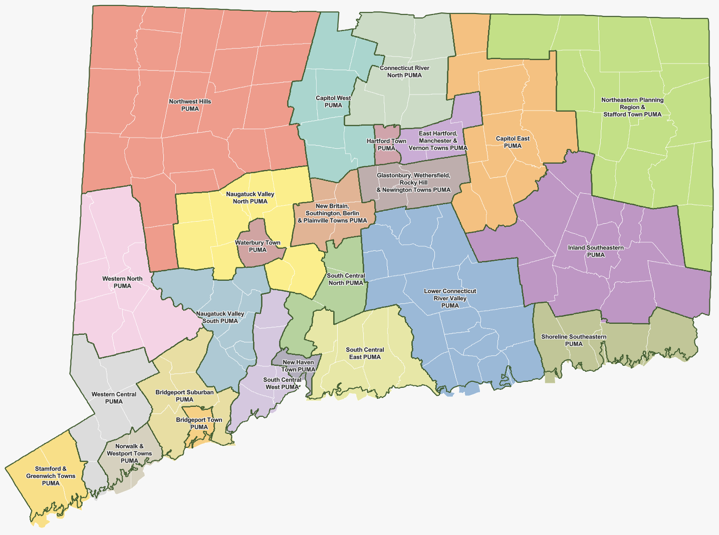
Town to PUMA Crosswalk
This crosswalk provides a many-to-one matching of Connecticut towns to 2020 Public Use Microdata Areas (PUMAs). There are 169 towns in Connecticut and 26 PUMAs.
Updating PUMA Boundaries for 2020
Throughout 2021 and 2022, CTData engaged in an outreach and decision-making process to update PUMA delineations. The sections below explain this process. You can download information about the delineation process as a pdf here.
2010 PUMA Boundaries
Issues and Challenges
CT had 26 2010 PUMAs
All PUMAs are within one county – they do not span county borders.
4 PUMAS are urban areas: Bridgeport, Hartford, New Haven, and Waterbury
4 PUMAs are the entire county: Litchfield, Middlesex, Tolland, & Windham counties
18 PUMAs represent clusters of contiguous towns
Population Trends of Current PUMAs
17 have lost population between 2012 and 2020. Two may be at risk of going below 100,000 and therefore would need to be combined with another PUMA (Waterbury PUMA and the Manchester and East Hartford PUMA are the smallest in the state, both around 107,500).
Largest losses:
New London County (North) from 139,983 to 131,302, a loss of 6%
Litchfield County, from 187,530 to 180,333, a loss of 4%
Delineation Process
What Is at Issue?
If Connecticut keeps its current counties and doesn’t move to COGs, we will need to identify which PUMAs may go below 100,000 over the next decade, or which PUMAs might be more useful if redrawn.
If Connecticut adopts COG boundaries for counties, data users will only have access to microdata that allows aggregation by COGs if PUMAs are reconfigured to be contained within COGs and not cross COG borders.
All 2010 PUMAs fall within current counties; they do not span county borders. If Connecticut adopts COGS, 9 PUMAs will span multiple COG borders. By crossing COG boundaries and including towns not contained within a COG, those PUMAs may not be as useful for regional planning groups.
CTData is working with data users to identify a Plan A (in case Connecticut keeps counties) and a Plan B (in case Connecticut moves to COGs).
Process
As a State Data Center, CTData defined 2020 PUMAs for the tabulation and dissemination of the decennial census, ACS, and PUMS data.
SDCs are encouraged to involve interested data users (e.g., tribal, state, and local governments, as well as regional planning agencies/organizations) with delineation to ensure PUMAs meet the needs of all stakeholders.
The ideal composition, as defined by the Census Bureau, includes:
PUMAs must be over 100,000 in population and ideally under 200,000
Making cities single PUMAs (in Connecticut’s case)
Individual tribal lands are maintained within PUMAs (not separating one tribal land across two PUMAs)
PUMAs should not cross county boundaries or other data products (POW and MIG PUMA data) will be negatively affected.
Timeframe:
November 2021 – January 2022 Define and return PUMAs.
November 2021 – May 2022 Process PUMA spatial updates.
Summer 2022 – US Census Release PUMA spatial products.
Census has requested county/COG decision by December 2021
Conference Session: PUMAS: What Are They and How Might They Change?
This video walks you through what PUMAs are and explains the requirements for creating the PUMAs for use with the data for the years 2020-2030. Information contained from this session is also included in the page below.
December 2021: Options became available for review on this page. These maps and tables allow you to explore 2010 PUMAs and identify the PUMAs that needed to be changed due to the use of planning regions for county boundaries (county equivalencies).
January 2022: CTData met with community members the week of January 3. This blog post captures the decision-making process and the updated maps that were considered the final decisions for these regions, pending further input from one region.