Get Out the Vote Data

This project is brought to you through the generous support of the Hartford Foundation for Public Giving.
Where are there higher and lower numbers of eligible, registered voters? What share of current residents voted in previous elections? These are some of the questions we explore annually with the Secretary of State’s Voter File. This project includes analysis of data about voting behavior in previous elections, interactive tools, and maps showing where eligible voters are.
This ongoing project is a partnership between CTData and the Hartford Votes Coalition and its members.
Learn about our latest project, in Partnership with the Hartford Votes-Hartford Votas Coalition: Building Democracy: Moving the Needle on Voter Engagement in Hartford. Information about Community Action Workshops will be available here in April!
Connecticut 2024 Election
Analysis Shows Declining Voter Turnout and Shifting Voting Patterns
Connecticut’s Secretary of the State has published results for the 2024 presidential election on their data portal. In this analysis, we explore changes in voter turnout and shifts in voting patterns using data from 2016, 2020, and 2024.
2024 Potential Voters Map
We’ve analyzed voter registration data in Connecticut, and created interactive web maps to help you find potential unregistered voters and help them get registered to vote. Zoom in to find specific neighborhoods, or look at the whole state to identify towns were there are potential, unregistered voters.

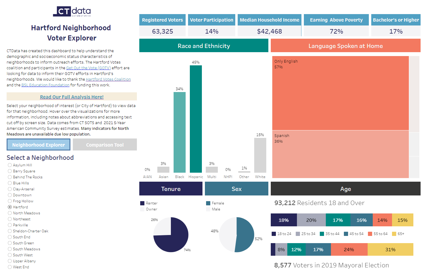
Hartford Neighborhoods Voter Data Story (2023)
With the 2023 municipal election in Hartford in mind, CTData met with Hartford organizations that were engaged in get-out-the-vote activities as part of the Hartford Foundation for Public Giving’s Get out the Vote grant program. Through interactive sessions, this group identified several questions that would be helpful in their efforts. Explore the projects below.
Building Democracy: Moving the Needle on Voter Engagement in Hartford
CTData is partnering with members of the Hartford Votes Coalition on a new research project called Building Democracy: Moving the Needle on Voter Engagement in Hartford. This study is run by CTData Collaborative (CTData) and funded by the Hartford Foundation for Public Giving.
2020 Presidential Election: Our Findings

The intricacies of how we vote was the subject of a great deal of attention in 2020. So how did Connecticut voters turn out? Read our analysis of the 2020 election turnout data.
Potential Voters
Map

Registering voters? Find the areas in your town where there may be higher numbers of unregistered voters with our Potential Unregistered Voters Map.
Voters Not Yet Registered

The Connecticut Department of Motor Vehicles (DMV) registers eligible voters automatically unless they decline. This map shows where there are higher numbers of eligible voters based on DMV records.
Voter Data Story

Where was the highest and lowest turnout in the 2016 election? How many unregistered voters are in my town? How many young people are registered in my town? Explore these questions and more in our Voter Data Story.
Voter Data Story PDF

Download the Voter Data Story PDF to print out or share with colleagues.
Ballot Drop Box Map

Where is the closest Ballot Drop Box? Find out on this map. Or embed it on your own website.